VERY COLD CLEAR WATER
Hidden Meadows & Fish
it's nicely off the road


-------

 .. Just what is the Upper Gallatin River?
.. Some would have it as everything above Taylor Fork. Some would have it as everything above Gallatin Gateway. Some would have it as everything above 4-Corners.
.. We tend to think of the Upper Gallatin River as that portion above the Highway 191 Bridge, (or thereabout,) in Yellowstone National Park.
.. It's just a matter of perspective: not being fluvial geologists, we feel free to call 'em as we like 'em.
.. It's in the confluence meadows, just above the bridge, that Fan Creek, Bacon Rind Creek, and the Gallatin River join.
.. It's here that the water is cold and crystal. It's here that the moose winter and the bears hibernate. It's here that few visitors bother to fish. We like it all.
.. The three creeks are each born in glacial cirques. All are associated with the remnants of cirque lakes. The Gallatin River finds it's origin in Gallatin Lake, (the NPS keeps this lake to themselves and restricts travel to the trail only - as if the bears care.)


.. The rivulets of the three creeks start above timberline and coalesce down-slope in a series of gradient changes that make for some wonderfully surprising meadows and equally surprising fishing opportunities.
.. For us, some of the meadows haven't been seen in over 40 years. But, with the aid of Google Earth and old photographs, we can revisit the cherished memories. And of course plan where to visit on those days that the legs are up to it.

 .. The fidelity of the images, generated by Google Earth, to the ground truth is astonishing for such a wonderfully free product.
.. Given this fidelity, and a U.S.G.S. topographic map it is possible to explore and anticipate your next escape.
.. Brownliners and blueliners already know this. We are just now discovering how useful it is.
.. Our current silliness involves updating our Yellowstone Fishing Maps on Google Maps. It's a wonderful tonic for insomnia.
.. As part of this project we started taking some more pictures of the various locales. So, a kindly neighbor suggested, (expletive deleted,) that all that pointing and shooting was unnecessarily burdensome and tedious.
.. He suggested that the Google Earth renditions would be more than adequate - and perhaps preferable because visitors could just go to the coordinates in the Google programs and discover the area for themselves. Why didn't we think of that?
.. There will still be photos from our trusty point & shoot, after all we do need to check and see if the rivers are still there.
-----
.. The first river being mapped and plotted with juicy fishing locales is the Gallatin River in Yellowstone National Park.
.. The interesting thing about the imagery of the Google programs is that it can be severely out of date.
 ..The examples shown in this post have imagery from as far back as the 80's. The landforms are recognizable and can be duplicated with a photograph.
 .. The river courses, (dynamic beasts,) are in some instances quite different. Happily, The major river segments have maintained their character over the decades.
.. So from time to time we'll be posting some images from the mapping project.
.. Naturally, it'll go slowly when there's catching to be had. It should progress more rapidly this winter.
-----
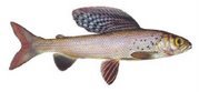
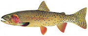
.. The Gallatin River has come into it's own. It continues to warm and the fisher folk are doing less dredging and a bit more floating with their bits of fluff... Your favorite attractor will do for surface fare.
 .. We like Royal Coachman and Adams, sizes can go to 8 or 10 for now. Even the little fishes will attack a high floating fly of whatever ilk - for the moment.
.. Fish the deep slow pools and undercuts in the morning with a Soft Hackle or small Woolly Worm.
.. Use a nymph; Bead Head Caddis, (or Prince,) during mid day in the riffles & at the heads of pools or the seams in bends.
.. As the shadows from the mountains creep over the river go up to the top and pound some noses.

-------
.


.jpg)