The Madison River Between The Lakes has awakened with a roar during this recent warming trend, and the neighbors have staggered and 'postholed' through the snow to get to the hungry fish. Our cool days and cold nights mean that brunch is a good time to start your day, followed by a leisurely 20 minute drive to the dam.
.. We've had various degrees of overcast, but the mid-day brightness has brought midges to the surface, and fish feeding just below the film.
.. The larger fish are just now entering this year 'round fishery, and spawning will start soon. The giant fish will be along in about 2-3 weeks. The fish are strong but sluggish; and the present, (about 900 cfs,) cold flows are ideal for leisurely subsurface drifts. The stretch of river from Hebgen Dam to the Island Bend is the most accessible right now. This is an excellent place for Spruce Flies,
 large Hare's Ear Nymphs, and Stone Fly Nymphs of various sorts.
.. Fish the slower holding water and the deep glides between rocks. Near the dam a fast sink tip with a size 6 - 10 Light Spruce Fly will dredge up some monsters if you have a 40 - 50 foot roll cast in your repertoire.
 .. This is a good time to use generalized flies such as a Hornberg. Start it dry, and then let it get good and wet and fish it on the swing, or strip it like a streamer.
  It's a good choice and avoids the numbing sensation when tying on several different flies.
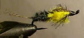
.. Another local favorite is the Llama, once a featured fly of the month at the Federation of Fly Fishers site. In these parts we substitute Yellow Bellied Marmot fur, or Badger, or even Red Squirrel Tail for the wing. The original recipe can be found HERE.
 .. We caught the neighbor, (we know that ratty old Dodge,) in the road channel at Island Bend - with a fish hung behind a rock. This channel gets to be nearly dry at low flows and even grows some terrestrial vegitation. Now is an excellent time to fish this rare water. For some reason the fish were taking a size 16 Elk Hair Caddis, it started out as a dry fly but was being fished on a twitched-drift midway in the water column and taking some nice fish.
 .. At the tailout of Island Bend is a broad swift glide that is best fished from the shore, or the tip of the island. The area is full of generously sized rocks with a bit less generous spacing between them. A herd of fish can hold here if undistrubed. We caught another angler standing where he should be fishing - did we mention the Utah license plate?
.. Between the Island Bend and Awkward Bend is the Campfire Run. Some intrepid locals
 trudge down here and fish the narrow and quick stretch right by Campfire Lodge. This is an excellent place to use Golden Stone Fly imitations or even the Rubber Legs variety. Fishing in this stretch is excellent right now with fish to 16" being taken with satisfying regularity.
.. Our favorite is, of course the Montana Duster, and the Yellowstone Spruce Fly.

.. The snow is a little deeper between Awkward Bend and 'Quake Lake, but it's worth a hike in the shadows to get to the Choice Hole. This deep undercut bank holds the pods of fish as they leave 'Quake Lake, and if you hit them in the nose they will respond. In a few weeks smaller & more imitative nymphs will be the preferred fare, but now it has to look like slow, easy groceries.
.. If the day is right and the Snow Flies abundant you may be blessed with surface feeding trout. Pick your favorite midge cluster and return home with a "shuldabeenthere" story.
.. Cabin Creek near the road is still frozen with snow on top. There are very few holes to aim at. Below the road and near the confluence there are good opportunities for short drifts in thin holding water.
.. How was the fishing? We don't count - and, anyway we don't know numbers that big. There was a neighborhood party between the Island Bend and the Choice Hole. Not that fishing was good, but side casts were ruled out.
.. The first substantive local fishing report is from our neighbors at Madison River Outfitters. They live and fish here. And usually get there first.
---------------------------
.. We'll be using a combination of Google Earth, and Platial Map Maker for illustrations this season. Verbal & written directions to places often fail for one reason or another. Although the maps are not 100% congruent, they are very close. Geo-referencing is exceptional and getting better by the day. The new version of Google Earth was released in January and is FREE. The map at the bottom of the page will stay there until it gets too full of places or notes. Maybe we'll break it down into river sections - who knows?---------------------
-- While flying around the world we spied a place that looked a bit fishy --
Recognize it, Tom?
Recognize it, Tom?


.jpg)


